Skagway is easiest to misunderstand when every image begins with a mountain and every itinerary begins with a gold-rush attraction. The town’s real advantage is not that it offers one oversized landmark. It is that several different systems can be read together: the northern end of Lynn Canal, a constrained working port, a town only a few blocks wide, the Skagway River corridor, road and rail routes, Dyea and the Taiya valley, and steep passage through the Coast Mountains toward Canada.
This guide uses those relationships as a planning tool. It does not provide a live timetable, trail condition, border instruction, price, product list, or weather promise. Those details change and belong to the responsible public agency or operator. Instead, it gives you a durable way to ask better questions, choose a realistic scale, and recognize when two places or routes should not be blended together.
1. Read the geographic section before the attraction list
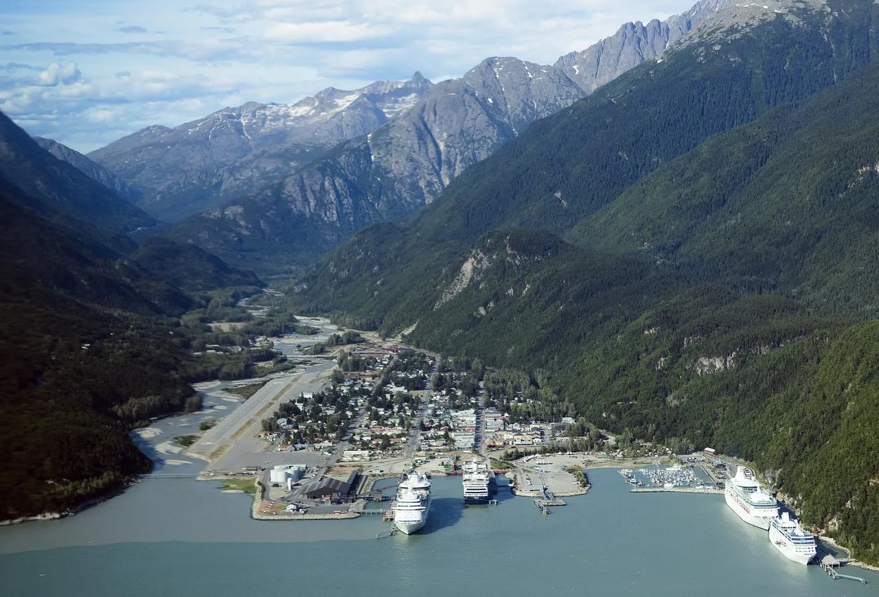
Skagway occupies a narrow, glacially shaped valley at the head of a long marine corridor. Water reaches far into the mountains; the town grid, river, transport infrastructure, and valley walls sit close enough to be understood on foot. From the lower town, routes turn inland and begin to gain grade. This transition—horizontal passage becoming ascent—is more useful than the generic idea that Skagway is simply “surrounded by mountains.”
Stand at a lawful public viewpoint where you can identify a lower datum: port edge, shoreline, river bar, boardwalk, street, roofline, or platform. Then look up the valley. The purpose is not to reconstruct a precise map from sight. It is to recognize four layers:
- Arrival layer: cruise, ferry, road, rail, or another arranged transport.
- Town layer: the walkable grid, public buildings, businesses, restored historic fabric, and daily municipal life.
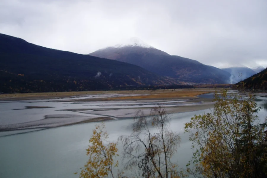
- Valley layer: the Skagway River, Taiya River, Dyea, forest, tidal flats, and access corridors.
- Route layer: White Pass, Chilkoot context, road and rail ascent, maintained trails, and international geography beyond town.
If an activity crosses several layers, include the movement between them in your time estimate. A map distance does not include waiting, boarding, group organization, road conditions, weather decisions, or the time required to return to a ship, ferry, vehicle, or other fixed departure.
2. Choose the scale of the day
Many disappointing plans are not badly chosen; they are badly scaled. A person with several uncommitted days can absorb weather and transport change differently from a visitor with a fixed same-day departure. An independent road traveler has different margins from a cruise passenger. A guided product and a self-directed walk have different responsibilities. Begin with the time that remains after all non-negotiable movement and buffers, not with the total time printed on an itinerary.
| Primary scale | Useful focus | Question to confirm |
|---|---|---|
| Compact town | Historic district, present community, public interpretation, material details | Which places are open and appropriate to enter now? |
| Town plus river or nearby landscape | Orientation between Broadway, the river, port, and maintained access | What are current surface, construction, and weather conditions? |
| Dyea and Taiya context | Tidal landscape, distinct townsite history, Chilkoot approach context | What access, resource protection, and road or trail guidance applies? |
| Pass or transport route | Grade, engineering, geology, weather, and international geography | What does the responsible operator or agency confirm? |
| Longer trail objective | Preparation, permits, conditions, equipment, turnaround plan | What current official information and competence does the route require? |
Choose one row as the primary commitment. A second row can become supporting context if it is adjacent and conditions allow. Avoid building a day that requires every element to operate perfectly. If weather closes the highest view, the town does not become a failed substitute; it becomes the correct scale for that moment.

Wild Adventure Yukon Tour into Canada including City and Summit
We are 100% Alaskan owned & operated - our focus is on giving you an amazing experience in Skagway on your trip to T...

Summit Experience & Yukon Suspension Bridge Tour
We are 100% Alaskan owned & operated - our focus is on giving you an amazing experience in Skagway on your trip to T...

Half Day Yukon Suspension Bridge & Summit Tour
The Yukon Suspension Bridge & Summit Tour is especially formatted for those who want to experience and photograph th...
3. Understand what Skagway was—and what it is
Skagway developed rapidly during the Klondike stampede as a transportation, supply, and community hinge. Gold was not discovered in Skagway. The town’s importance came from movement toward the interior, the work and business that supported it, and later transport and conservation histories. That distinction matters because it prevents the streets from becoming a generic “where the gold was” set.
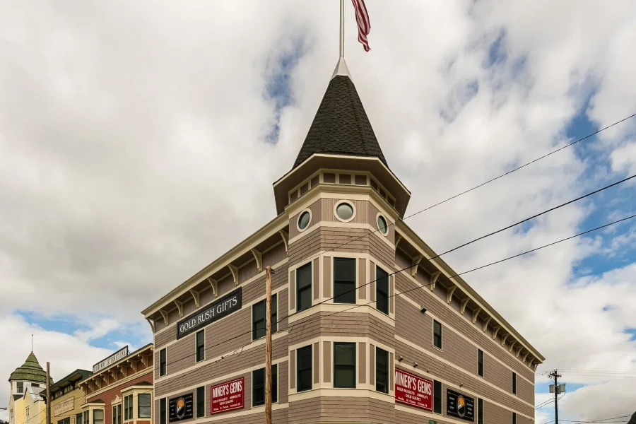
Restored false fronts and boardwalks are genuine visual evidence, but they should be read in the present tense. Buildings have current uses. Streets carry residents, workers, deliveries, maintenance, visitors, and public services. Port activity involves cruise, ferry, freight, fuel, rail, small craft, security, and community access. Winter changes the population, light, sound, and pace without erasing the town.
A useful town walk includes three kinds of attention:
- Interpretive attention. Read a primary or official source before repeating a dramatic anecdote. Ask who created the account and what period it covers.
- Material attention. Notice boardwalk edges, painted siding, repaired windows, drainage, rock cuts, platform boundaries, and the physical work of keeping a northern town functioning.
- Contemporary attention. Notice current public spaces, local production, ordinary errands, accessible routes, and the difference between a visitor-facing performance and a resident’s daily environment.
Photography should follow the same rule. Do not block a walkway, doorway, accessibility route, loading area, rail boundary, or worker for a “historic” frame. Do not treat a person as period scenery because the building behind them is old.
4. Place Tlingit history before the boomtown
The Skagway and Taiya valleys were not empty corridors waiting for prospectors. Tlingit trade and packing routes connected coastal and interior worlds before the stampede. Dyea’s history in particular cannot be responsibly told as a short-lived rival boomtown without that longer context.
This website does not convert Tlingit place names, formline, clan crests, basketry, regalia, language, or sacred references into decoration. Cultural material should come through Tribal, artist-led, or primary interpretive sources with the right attribution and context. A general travel guide should also resist a common mistake: using one historical image or one artwork to imply a single timeless Indigenous culture.
When an official interpretation gives a Tlingit place name, follow its spelling, explanation, and source rather than improvising. When a contemporary artist or cultural program appears, name the artist and affiliation accurately and review image and artwork rights. Respect includes knowing when a beautiful design is not yours to reuse.
5. Keep Skagway and Dyea distinct
Skagway and Dyea are close enough to appear in one trip but different enough to require separate mental maps. Skagway connected to the White Pass route and developed durable transport infrastructure. Dyea connected to the Taiya valley and the Chilkoot Trail approach. The latter’s open tidal flats, river movement, forest edge, sparse town traces, and resource sensitivity produce a quieter visual and practical rhythm than Broadway.
Do not describe Dyea as an abandoned attraction that exists only for imaginative gold-rush reconstruction. Absence is evidence, but it requires interpretation. River channels shift. Vegetation returns. Archaeological and historic resources can be fragile. Designated access protects both the place and the visitor’s ability to understand it.
If Dyea is part of your plan:
- Confirm current road, trail, weather, and site guidance.
- Use designated routes and avoid moving or collecting material.
- Separate the former townsite, Taiya River landscape, and Chilkoot route in captions.
- Allow more time than a distance estimate suggests.
- Carry an alternative if conditions or access change.
For more background, use the Dyea & Taiya guides rather than treating a tour-card title as the complete history of the place.
6. Read White Pass as grade, not railway decoration
The White Pass story includes geography, engineering, weather, international connections, labor, business, and environmental consequences. The railway is a living operator and an important part of the region’s transport identity, not a graphic theme. A generic wheel, spike, herald, or stripe borrowed from railway trade dress would confuse an independent guide with the operator itself.
Whether you experience pass context by road, rail, view, or historical interpretation, keep three boundaries clear:
- Place boundary. International routes continue beyond Skagway; do not caption Canadian or Yukon scenery as though it lies inside town.
- Operator boundary. A provider or transport operator supplies current schedules, terms, accessibility, product facts, and service decisions.
- Weather boundary. A planned route does not guarantee a view, a particular condition, or the same experience in every direction.
The most destination-specific observation is the controlled change of grade. Low water and town datums give way to cuts, crossings, and narrow route openings. That is why the Rising Datum design uses one measured lift instead of an illustrated train.

Summer Sled Dog Remote Yukon Camp & Summit Tour
We are 100% Alaskan owned & operated - Our focus is on giving you an amazing experience in Skagway on your trip to T...

White Pass Deluxe Tour from Skagway
Join a 3-hour highlights tour of Skagway with a knowledgeable guide. Hear stories from the Gold Rush and see amazing...

Yukon Husky Puppy Play Time & Summit Tour
We are 100% Alaskan owned & operated - Our focus is on giving you an amazing experience in Skagway on your trip to T...
7. Treat the port as working infrastructure
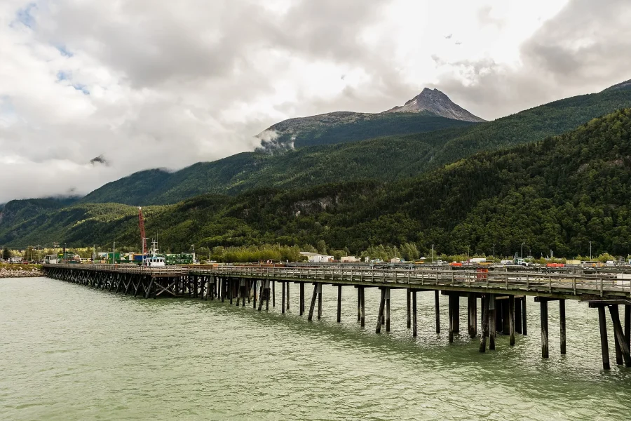
Skagway’s port is visually dramatic because large and small systems share constrained space. Cruise ships may dominate a particular view or day, but they do not define every user. Ferry operations, freight, fuel, rail, small craft, pedestrian movement, security, maintenance, and community planning also matter.
Use marked pedestrian routes and respect fences, signs, working surfaces, and instructions. A clear camera angle is not permission to enter an operational area. Port photography should include boundaries and people with purpose rather than presenting infrastructure as an empty industrial mood board.
For planning, separate the arrival promise from the town plan:
- Record the official return requirement before leaving the arrival area.
- Understand how you will move between the berth, ferry, vehicle, railway, or meeting point and town.
- Keep required documents and provider instructions accessible.
- Do not rely on a website guide for last-minute operational changes.
8. Plan for wind, cloud, and uneven light
Skagway can be drier than nearby Southeast Alaska communities because of its position within the mountains, yet this is not a promise of stable sunshine. Marine air, valley orientation, season, elevation, and interior influence can create quick changes. The waterline can feel different from a sheltered street. Low cloud can obscure the pass while leaving town clear. Wet surfaces, shade, and wind can alter comfort and traction even without sustained rain.
Carry adaptable layers and protect equipment. Confirm current alerts close to the outing. If a high view disappears, use material and spatial details that flat light often reveals well: siding color, river silt, boardwalk texture, cloud movement on a rock cut, or the narrow relationship between roofline and mountain wall.
A weather-aware plan has at least two branches:
- A primary route that fits the current information and your ability.
- A town-scale or indoor alternative that remains meaningful without pretending it is the same experience.
9. Approach trails without conquest language
Skagway’s route history can invite language about proving toughness, conquering a pass, or repeating hardship. That framing is neither necessary nor safe. Historic routes involved labor, animal deaths, avalanche, displacement, environmental impact, and uneven power as well as endurance and engineering.
For a contemporary trail objective, use present guidance rather than a romantic story. Evaluate:
- Authority and access
- Current closures, permits, border requirements, and designated routes.
- Whether a transport reservation or arranged return is part of the plan.
- Conditions
- Weather, water, snow, surface, wildlife, smoke, daylight, and recent reports.
- What can change after the last update.
- Personal readiness
- Distance, elevation gain, pace, equipment, food, water, navigation, and first-aid capacity.
- A turnaround decision that does not depend on reaching a viewpoint.
- Group and resource care
- The least experienced person’s needs.
- Waste, surfaces, campsite rules, noise, cultural sites, and wildlife distance.
Do not treat another visitor’s social post, an old trip report, or a product description as a substitute for official current information.
10. Let provider products remain provider-owned
The Tours page can display provider-owned products. Product titles, photographs, descriptions, ratings, review counts, durations, prices, availability, and booking links come from that provider surface when configured. This editorial guide does not fabricate them, and the theme does not decide which injected article product appears or how frequently it is placed.
Use editorial context to compare scale rather than marketing adjectives. Ask where the product actually goes, what transport it uses, which accessibility and cancellation terms apply, what return margin you need, and which facts require direct confirmation. A beautiful card is not proof of availability or suitability.
The same separation applies to lodging. The Where to Stay guide explains location and route questions. A configured lodging provider supplies live inventory and transaction terms.
11. Build a route-literate sequence
After choosing a scale, assemble the day in geographic order. A compact example might begin with arrival orientation, move into current Broadway, use a public interpretive stop to deepen history, cross toward the river or a nearby material detail, and return with a realistic buffer. A longer example might dedicate the primary block to a managed route and use town context before or after—not attempt both Dyea and pass ascent as casual add-ons.
Write the sequence in plain language:
- Where do I begin, and what fixed departure governs the day?
- What is the one primary scale?
- Which movement between places consumes time or depends on a provider?
- What current source must I check?
- What is the meaningful lower-scale alternative?
- How will I return with margin?
This method prevents a map from becoming an unrealistic list. It also leaves room to notice a present community rather than racing between historical labels.
12. Photograph relationships, not trophies
A Skagway photograph becomes more informative when it contains a lower reference and a route upward: dock edge to valley wall, boardwalk to street end, river bar to pass, platform edge to rock cut, or quiet Dyea flat to forest. Protect the actual subject in a mobile crop instead of assuming that a panorama will survive.
For people, seek consent for close portraits and describe what the person is doing. Do not use residents as colorful scenery, a Tlingit artist’s work as anonymous texture, or a crowd as the whole summer community. For historic photographs, preserve source context and do not crop out the evidence that makes the image interpretable.
At working transport areas, obey operational boundaries. At cultural and archaeological sites, avoid revealing sensitive details or reproducing protected work without permission. A photograph that cannot be made respectfully is not required.
13. End below the summit
The widest view will often be the first thing remembered, but a complete understanding of Skagway rests on lower details: sediment, boardwalk, painted wood, freight edge, public doorway, winter light, a historical source, or the direction of the valley. Those observations explain why the passage climbs here.

Yukon Suspension Bridge Tour from Skagway
Cross into the Yukon on a small-group tour from Skagway, traveling the stunning White Pass with a locally owned, own...

Skagway Shore Excursion: Yukon Discovery Tour
Take the ultimate Yukon experience with the Yukon Discovery Tour! Drive through the White Pass and into Canada and t...

Skagway Shore Excursion: Full-Day Tour of the Yukon
Enjoy your port time in Skagway with a full-day shore excursion by mini-bus into the Yukon, Canada's westernmost ter...
Use Guides for durable context, the configured provider surface for changing products, and the responsible agency or operator for current access and safety. Keep Skagway and Dyea distinct, place Tlingit history before the boomtown, and let the year-round community remain visible after the ship or train leaves the frame.
Still comparing Waterline White Pass: Route Literate?
Ask for tour ideas, hotel suggestions, or a simple trip plan that combines both.